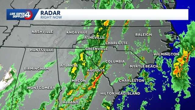
Severe storms are sweeping across the Upstate of South Carolina and Western North Carolina this Monday, bringing with them the threat of damaging straight-line winds, isolated tornadoes, large hail, and heavy rainfall that could disrupt the morning commute.
Forecasters issued an Impact Day alert for Monday, signaling a heightened potential for significant weather-related disruptions and dangers. An Impact Day alert means emergency crews, cops, and power companies get ready fast—they pre-position resources and prepare for quick action. The severe weather system is expected to move through the region between 4 a.m. and noon. Specifically for the Upstate, residents can anticipate the main impact from 5 a.m. until noon, coinciding directly with peak morning travel times. This timing means commuters should prepare for hazardous conditions, including reduced visibility from heavy rain and potential road blockages from downed trees, leading to significant delays on their way to work or school. Authorities advise delaying non-essential travel if possible during these hours.
There are several threats here, and each one needs different preparation. Damaging straight-line wind gusts, distinct from tornadoes but equally destructive, represent a significant threat. These winds can hit 60 mph or harder—they'll snap trees, knock down power lines, and wreck buildings. Isolated tornadoes are also a possibility, a risk that underscores the importance of staying alert to NOAA Weather Radio alerts and local emergency broadcasts. Isolated tornadoes are tougher to pin down than big outbreaks, so you need to stay alert. Big hail will smash car windshields, destroy crops, and punch holes in roofs and skylights. Heavy rain also means flash flooding in low spots, cities with bad drainage, and near creeks that'll overflow fast. The National Weather Service in Greenville-Spartanburg is tracking this and issuing alerts to help people get ready. The worst should move east by afternoon, but if the storm slows down, the danger sticks around longer.
Preparing for and Responding to Severe Weather
With all these threats, you need to be ready. Get weather alerts from your phone, local news, and a weather radio so you don't miss anything. Stock an emergency kit with flashlights, batteries, canned food, water, and any meds you need in case the power goes out. If a tornado warning hits, get to an inside room on the ground floor of a solid building, away from windows. For straight-line winds, staying indoors and away from windows is also recommended. Spring is peak severe weather season here, but cold fronts in late winter can still pack a punch—the region's always vulnerable to big storms. Know the difference: a watch means conditions could get bad, a warning means severe weather is coming now.
Beyond the Immediate Storm
When that cold front moves out Monday, it's not just clearing up—the whole weather pattern flips. Western North Carolina will get snow by afternoon, mostly in the mountains, with light buildup on high roads. Going from thunderstorms to snow fast means mountain roads will get icy quick. Winds will also pick up significantly behind the front, ushering in much colder air. A Wind Advisory is up for the mountains above 3,500 feet—expect 50 to 60 mph gusts. Those winds will make it hard to drive trucks and RVs, knock down more power lines, and make being outside risky.
Tuesday and Wednesday stay cold enough to get Impact Weather Day alerts. Overnight temps will drop to the teens and low 20s, and wind chills will make it feel even colder. That cold will freeze pipes and put people without heat in real danger. Farmers need to protect early spring crops from the freeze. This flip from warm storms to arctic cold is what happens when a strong cold front moves through—it's a classic pattern for the East. Keep yourself, your pets, and livestock warm and protected from the cold.
With severe weather impacting the morning commute and frigid temperatures following closely behind, residents should stay updated with the latest weather advisories throughout the week.