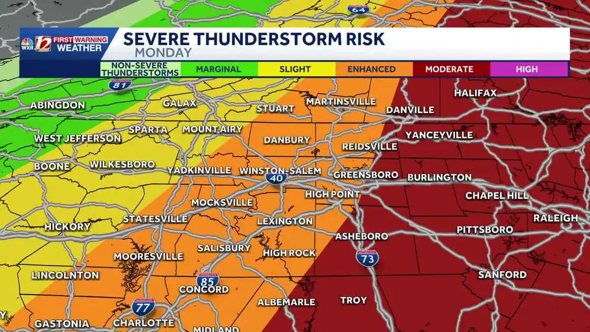
A powerful cold front moved through the Carolinas on Monday, March 16. Central North Carolina, including Greensboro and the Piedmont Triad, faced a rare Level 4 severe weather risk with forecasters warning of destructive winds and strong tornadoes.
Imminent Threats and Timing for the Triad
Parts of the Piedmont Triad, including Greensboro and Winston-Salem, were under an enhanced and moderate risk of severe storms. Authorities issued tornado warnings for the region as the weather system intensified. The primary threats include widespread wind damage, with gusts potentially exceeding 74 mph, and the possibility of strong tornadoes, specifically EF-2 or stronger.
Peak severe weather threats for the Piedmont Triad were expected from 10 a.m. through at least 3 p.m., particularly near Burlington in the eastern Triad. Earlier in the morning, between 5 a.m. and noon, the Mountains and Foothills experienced severe storms, with scattered severe activity impacting the Piedmont Triad during the morning commute. The front's progression west to east meant rising threats for the Triad as the day progressed, prompting urgent calls for preparedness.
Understanding the Elevated Risk
A Level 4 risk is rare for central North Carolina—that's how serious this threat is. The Level 4 risk (sometimes called 'moderate' in advisories) means widespread severe weather is likely. Conditions favor multiple severe thunderstorms capable of producing long-track tornadoes and damaging winds.
This isn't just a few scattered storms—it's a widespread dangerous weather pattern. The same cold front triggered blizzard warnings in the Midwest and brought destructive wind and tornadoes across the Deep South and Southeast. Strong tornadoes could develop Monday along a path from South Carolina to southern Pennsylvania.
Critical Safety Measures for Residents
North Carolina Emergency Management wants residents to review their severe weather plans now. That means finding safe shelter before storms arrive—especially critical for people in trailer homes or manufactured housing that won't survive the expected winds and tornadoes. People working in warehouses, gymnasiums, or outdoors need to know where their nearest safe shelter is.
You also need multiple ways to get warnings and updates. Residents should enable emergency alerts on their cellphones. They should also follow updates from the National Weather Service office in Raleigh, local media outlets, and Ready Guilford. The state also provides comprehensive tornado safety information on weather.gov/safety/tornado-during and general preparedness resources at readync.gov.
A Widespread and Destructive System
This severe weather hitting North Carolina is part of a massive system affecting the entire eastern U.S. The system's already caused major problems in other parts of the country. The scale of this system shows just how intense and widespread the threat is.
The cold front's energy created unstable conditions that fuel the tornado and wind threats. This system can cause serious damage across a huge area. The focus for Monday remained on ensuring public safety as the destructive path continued its eastward trajectory.
Officials are watching closely and urge people in the eastern Piedmont Triad to stay alert through the afternoon as threats continue.