A tornado watch means conditions are ripe for tornadoes to form, signaling residents in affected areas to stay alert for severe weather. Recently, specific counties in Kentucky and Indiana were placed under a tornado watch until 5 a.m. Monday, with severe storms expected to move through between 10 p.m. Sunday and 2 a.m. Monday.
What a Watch Means for You
When the National Weather Service (NWS) issues a tornado watch, it signals that atmospheric conditions are favorable for thunderstorms capable of producing tornadoes in and around the designated watch area. This isn't a definitive prediction of a tornado striking a specific spot, but rather a critical alert for residents to remain vigilant, closely monitor weather updates, and prepare to act swiftly should a tornado warning be issued. A tornado warning, in contrast, means a tornado has been observed visually or detected by radar, necessitating immediate protective actions.
Meteorologists often scrutinize weather patterns for specific indicators, such as small breaks within a line of storms or individual cells forming just ahead of a main system. These particular formations can enhance inflow and rotation, making them more prone to spawning tornadoes. It's also important to understand that even during significant tornado outbreaks, it's rare for every location within a warning area to experience a direct hit. Tornadoes, if they develop, typically affect only a small, localized section of the warned zone. This distinction between a "watch" and a "warning" is crucial for public safety, guiding people on when to prepare versus when to take immediate shelter.
Broad Regions Under Severe Threat
A sweeping storm system recently triggered tornado watches and severe weather alerts across several states, driven by warm air pushing north from the Gulf of Mexico. This powerful system, which was simultaneously delivering snow and icy conditions across the Midwestern United States, also had a significant cold front at its tail end, bringing severe weather threats to parts of the South and potentially setting up a major threat for the Mid-Atlantic states.
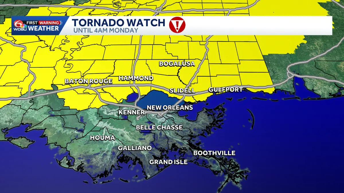
In Southeast Louisiana and South Mississippi, residents were placed under a tornado watch as the system approached. Despite a quiet, warm day initially, forecasters anticipated showers and thunderstorms, particularly after midnight, with a main line of storms expected to move through affecting much of the region. The highest level of threat, a "Level Three Enhanced Risk," was generally positioned north of these areas, but the entire region remained under the watch.
Further east, Virginia experienced an "ABC 13 Weather Alert Day," signaling a batch of strong storms that would sweep across the entire viewing area. The primary concern for severe thunderstorm and tornado warnings was expected between approximately 9 a.m. and 5 p.m. on Monday. The storms were forecast to move from west to east, with isolated cells potentially forming even before 9 a.m. Residents in counties bordering I-81, including Roanoke, Blacksburg, and Lexington, were slated to experience the storms first. From there, the system was expected to intensify as it moved eastward, crossing the Blue Ridge into Central and Southside Virginia, impacting cities like Bedford, Lynchburg, Farmville, Amherst, Nelson, Martinsville, Danville, and South Boston through the late morning, lunch, and afternoon hours.
Meanwhile, Kentucky and Indiana also saw numerous counties under tornado watches. In Kentucky, counties such as Adair, Breckinridge, Bullitt, Carroll, Grayson, Green, Hardin, Hart, Henry, Jefferson, Larue, Marion, Meade, Nelson, Oldham, Shelby, Spencer, and Trimble were under alert. Across the Ohio River, Indiana counties including Clark, Crawford, Floyd, Harrison, Jackson, Jefferson, Jennings, Orange, and Scott were similarly affected. For both states, these tornado watches remained active until 5 a.m. Monday, with the most severe storms projected to arrive between 10 p.m. Sunday and 2 a.m. Monday.
Safety and Preparedness Measures
Beyond the direct threat of tornadoes, these widespread storm systems often bring a host of other severe weather hazards. Meteorologists frequently issue severe thunderstorm warnings for straight-line winds, with forecasts indicating peak gusts could reach 60 to 70 miles per hour. Hail also poses a significant risk during these events. It’s important for the public to understand that even within a severe thunderstorm warning area, not every single location will necessarily experience storm damage.
Public safety officials emphasize specific protocols during severe weather. Schools, for instance, are equipped with comprehensive severe weather safety plans. Parents are strongly advised against attempting to drive to schools to retrieve their children if a tornado warning is in effect. Children are typically much safer sheltering inside the school building, which is designed to withstand such events. If tornado warnings coincide with the end of the school day, schools generally hold students securely inside until the immediate threat has passed.
The impact of these systems extends beyond the direct storm passage. Strong winds often persist throughout the day, even after the main line of thunderstorms has moved away. For example, in parts of Virginia, strong winds were expected to continue into Monday night and Tuesday morning, long after the storms had advanced east of Lynchburg and Danville by late afternoon. Residents should stay continuously updated through local news and weather services, have a clear understanding of their specific local alerts, and maintain a personal safety plan ready for immediate implementation. The ground may also feel wet from humidity, and temperatures can be near or over 60 degrees, contributing to the "storm day" feel before the main weather event hits.
Once the cold front has fully moved through an area, the severe weather threat typically diminishes, leaving behind conditions of lingering cloud cover and only spotty, non-severe showers.