A powerful winter storm, anticipated to be the largest of the season, has triggered hundreds of flight cancellations at Minneapolis-St. Paul International Airport and prompted emergency declarations across the Twin Cities, threatening to disrupt travel and daily life through Monday.
Air Travel Grinds to a Halt Amid Storm Threat
Travelers attempting to navigate Minneapolis-St. Paul International Airport (MSP) faced widespread disruptions as a major winter storm descended upon Minnesota. By Sunday, FlightAware reported a staggering 610 flights canceled at MSP, with an additional 14 delayed, painting a grim picture for those hoping to fly. This followed a challenging Saturday, which saw 35 departures and 31 arrivals canceled early in the day, escalating to 66 arrival and 55 departure cancellations by 7:30 p.m., alongside dozens of delays.
Major carriers, including Delta, Sun Country, American Airlines, and United Airlines, responded to the impending weather by issuing travel waivers. These waivers allow passengers with affected flights to rebook without penalty, a common practice during severe weather events. Airport officials proactively advised all travelers to check directly with their airlines for the most current flight information, emphasizing the rapidly changing conditions. Many passengers tried to escape the snow by flying out ahead of the storm's main impact, creating a sense of urgency at the airport.
The cascading effect of these cancellations extends beyond mere inconvenience. It means missed connections, stranded travelers, and significant logistical challenges for airlines and airport staff. Ground crews grapple with de-icing procedures and maintaining runways, while airlines work to re-route aircraft and accommodate thousands of disrupted passengers. The financial implications for both airlines and travelers are substantial, highlighting the storm's far-reaching economic ripple.
State and City Mobilize for Emergency Response
Minnesota Governor Tim Walz took decisive action, signing an executive order to authorize the Minnesota National Guard for emergency operations. This deployment underscores the seriousness of the storm, allowing the Guard to support local authorities with critical resources until the severe conditions subside. Such a move is reserved for events expected to overwhelm standard emergency services, indicating the anticipated scale of the winter blast.
In the Twin Cities, mayors Kaohly Her of St. Paul and Jacob Frey of Minneapolis jointly announced snow emergencies during a Saturday press conference. These emergencies, set to take effect at 9 p.m. on Sunday, impose strict parking restrictions designed to facilitate snow removal operations. City officials urged residents to move their vehicles by Saturday to avoid towing and ensure plows could clear streets efficiently. Failure to comply with snow emergency rules typically results in fines and impoundment, adding another layer of concern for residents.
The measures reflect a coordinated effort to protect public safety and maintain essential services. A NEXT Weather Alert remains in effect into Monday, signaling continued hazardous conditions. State and local agencies are preparing for potential power outages, road closures, and the need for emergency assistance, demonstrating the comprehensive nature of the storm response.
Storm's Fury: Heavy Snowfall and Treacherous Conditions
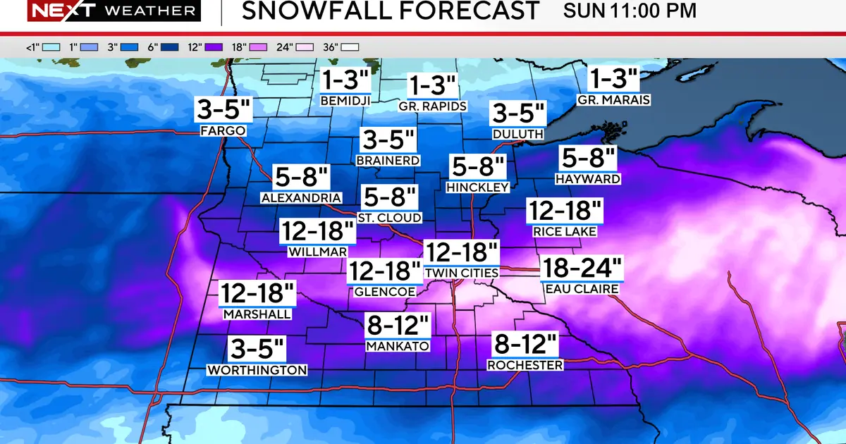
Forecasters predict the Twin Cities metro area will see between 12 to 18 inches of snow, with isolated spots in Wisconsin potentially exceeding 18 inches. The heaviest snowfall is expected overnight Sunday, with rates of 1 to 3 inches per hour, making travel exceptionally dangerous. These intense snowfall rates can quickly reduce visibility to near zero, creating whiteout conditions.
Compounding the heavy snow are powerful winds, with gusts anticipated to reach 30 to 50 mph. These winds will lead to significant blowing and drifting snow, further obscuring roads and making travel nearly impossible. Blizzard warnings are in effect for Sunday morning and afternoon, covering a wide area. While areas closer to Interstate 90 might experience a mix of sleet and ice, slightly reducing snow totals, the NEXT Weather team still warns that travel area-wide will be very difficult, if not impossible, through Sunday afternoon.
Such extreme weather not only affects transportation but also poses risks to infrastructure. The combination of heavy, wet snow and strong winds can stress power lines and trees, increasing the likelihood of widespread power outages. Residents are advised to prepare for potential disruptions to utilities and to have emergency kits ready.
City-Wide Solutions for Residents
To assist residents with parking during the snow emergencies, both Minneapolis and St. Paul have opened temporary free parking options. Minneapolis has made parking available at the Salvation Army and farmers market lots, free until Wednesday at 8 p.m. Additionally, Parking Ramp A in downtown Minneapolis will open on Sunday, charging residents only $1 for its use. These measures aim to prevent vehicles from obstructing snowplows and provide safe alternatives for residents.
St. Paul has also opened the Block 19 ramp in downtown for free parking for its residents, starting Saturday at 5 p.m. The city plans to open additional St. Paul park lots as they become available, encouraging residents to check the city's website for updates. In a direct impact on daily life, St. Paul officials announced there would be no garbage pickup on Monday, advising residents to hold their refuse until the next scheduled collection.
These municipal efforts are crucial for managing the aftermath of such a significant storm. By providing clear guidance and resources, cities hope to mitigate the chaos and ensure a smoother recovery process once the snow subsides. The proactive steps taken by city leaders highlight the comprehensive preparation required to handle a winter event of this magnitude.
Even as the snow tapers off into Sunday evening, gusty winds are expected to persist into Monday. This will likely cause lingering travel issues for the morning commute, especially with continued blowing snow and potentially icy patches on roads.
The NEXT Weather Alert will remain in effect until Monday, with authorities urging continued caution for anyone planning to travel.